I first encountered Deep Creek the way I suspect most people do: in a car. As Highway 2 makes a beeline west out of Spokane, it passes the main gate to Fairchild Air Force Base. Then, in about the time it takes to peel an orange, the highway dips abruptly into a ravine, crosses a bridge, and continues past a sign announcing the small community of Deep Creek.
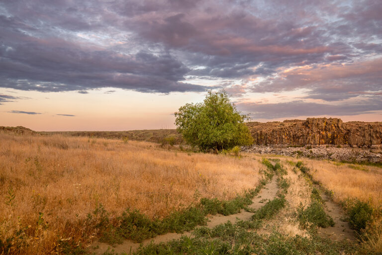
As for the creek itself, for most of the year there is barely any water at this crossing. This is a noteworthy riddle. The discernible headwaters for Deep Creek are only a few miles away, in a maze of wetlands west of Four Lakes. Although the creek sometimes floods dramatically during a rain on snow event in late winter—or in a spring as relentlessly wet as this one—it’s too small and ephemeral to attract kayaks or canoes. Indeed, hiking along and across the creek bed is the best way to explore the ravine from the trailhead off Seven Mile Road, about a half mile west of the Spokane River. So it is curious as to how such a trickle of water could create such an extraordinary crease in the earth.
The answer is: it didn’t. It’s just a geologic mind trick. The farther you head downstream, to the north and east, the more magnified the natural ruse becomes. You begin to encounter massive basalt outcroppings. As the creek approaches its confluence with the Spokane River, it passes below enormous basalt cliffs, reaching upwards of 400 feet above the floor.
The towering cliffs display contours and shapes seen in many of the more familiar coulees in eastern Washington’s channeled scablands, with rounded thumbs, occasional spires and massive teardrops of basalt. This only makes sense because these distinctive creations were formed by the same torrents of late Pleistocene epoch floodwaters, the largest of which, from ancient Lake Missoula, flowed through the Spokane valley before turning southward, eventually blasting through the Columbia River gorge to the Pacific.
The basalt forms in the impressive rimrock heights above Deep Creek bear a striking resemblance to those exposed at Northrup Canyon, just east of Grand Coulee, where, with less tree cover, you can better imagine what the power of the ancient Lake Missoula flood waters would have looked like. Good luck trying to imagine the sound, it had to have been deafening. At what is now Deep Creek, the flood waters overwhelmed the landscape, exploited a weakness in the underlying, fractured basalt, and simply smashed a pathway out to the west plains and beyond.
Perhaps the best-known instance of the ancient Missoula floodwaters doing the excavation for a present day stream, is the Palouse River canyon, eighty miles south of Deep Creek. Near the small town of Hooper in southwest Whitman County, the Palouse River makes a sharp left turn. It is at this point that the Palouse leaves behind the now dry river course it used to follow, heading west and then south before it reached the Columbia River near Pasco. Today the Palouse makes a shortcut down to the Snake, a shortcut created entirely by the almost unimaginable flood waters that hammered through a divide and then carved the canyon that now bears the name of the river that appropriated it.
After the famed scabland geologist J Harlan Bretz did his early field work on the Palouse River canyon in the 1920s, he discovered something amazing about the Snake River. He not only found enormous sand and gravel bars in the Snake upstream from where the Palouse empties into the Snake, but he noticed by their composition and shape that they could have only been created by water moving east. Again, this is at a place where the Snake River is actually headed west. The extraordinary flow reversal could only be explained by accounting for the enormous inflow of Lake Missoula floodwaters from Palouse and nearby Devils Canyon, literally causing the flow of the Snake to temporarily reverse itself for several miles.
Deep Creek isn’t remotely comparable to the Snake, nor the Palouse. But if there’s an added dash of geophysical humor to Deep Creek, it is that today it weaves and tumbles northward in the same canyon carved by ice age floodwaters that were headed the other way.
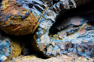
I’m surprised at how narrow it is in places, and intrigued with the variety of metamorphic and igneous rocks that litter the ravine and form enormous deposits on its margins. There are also places where the basalt seems to come alive with ornate fractures and fists of suddenly cooled lava that were formed under dynamic conditions, clearly through interactions with water. I’ve even found glossy black shards of obsidian which (thankfully for those of us who climb on the basalt outcroppings) are rare in eastern Washington’s lava fields.
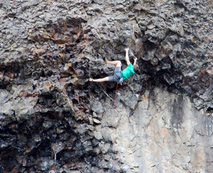
The main part of the canyon is within Riverside State Park, and is well-known to rock climbers. Actually, whether you are a serious climber or not, there is a near irresistible temptation to climb these rocks, especially on the large outcrops of exposed basalt near the creek’s confluence with the Spokane River. You don’t have to be a geologist to marvel at what you’re climbing on. As a photographer, I’ve come to appreciate the Deep Creek ravine as a texture garden in the variety of rocks, plants, water, ice and wood that is stripped, scoured and sun-bleached. In the rocks alone, there are signs of spasms and large erupting gas bubbles, explosions of shape and color that got frozen in time and then uncovered by the catastrophic floodwaters blasting through from Montana.
In such moments of discovery, it’s as though timescales merge. The basalt floes are roughly 15 million years old. The flood waters that ripped the top layers off the basalt were unloosed roughly 15,000 years ago.
Preposterously, I can’t help but bring my time—human time—into the equation, and it’s usually measured in a few very precious hours that I can be away from all the other places I’m expected to be. Just like the rest of the world, there’s no shortage of reminders and enforcers that our clocks reign supreme. What a blessing it is to be in a natural setting that so quietly and profoundly refutes this illusion.
All of this means I can offer the very highest compliment to the Deep Creek ravine—as with other such sanctuaries, it makes me lose track of time altogether.