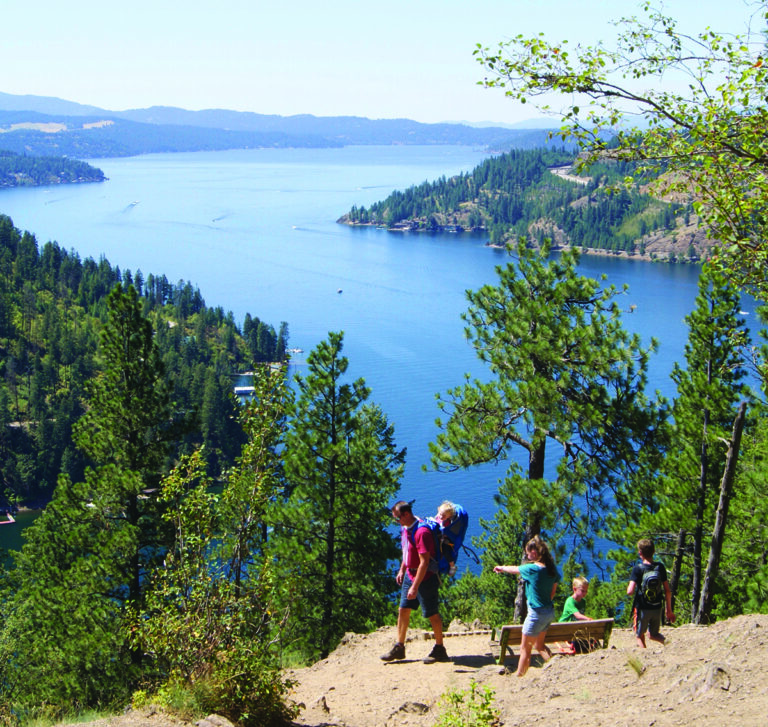
IT’S A UBIQUITOUS SUMMER PHRASE in Spokane: “Going to the lake.” For some, the body of water referenced is Coeur d’Alene; for others, Newman or Hayden lakes. For many, though, the “lake” in the phrase is Priest, probably the most popular water destination in the area and certainly the most scenic (apologies to Pend Oreille enthusiasts). As is often the case when those two words (“popular” and “scenic”) inhabit the same sentence, the conflicting energies of access and conservation can conflict. For Priest Lake, this friction is certainly a fact; for nearby Upper Priest Lake, the conflict would probably be better described as a crisis (***more on this later).
Still, despite overuse and abuse, Upper Priest Lake remains a beautiful and worthwhile paddle destination, probably one of the premier lakes of this sort in the Northwest. Let’s hope that, in the next decades, this statement can retain some semblance of truth.
1. BACKGROUND AND FACTS
In 1846, missionary Father Desmet originally named this body of water Lake Roothan after the controversial Jesuit Jan Roothan of Amersterdam; about twenty years later, Captain John Mullan changed the name to Kaniksu, which probably means “black robe,” referring, of course, to the garb of the Jesuit missionaries. Over the next fifty years, the name was simplified to Priest Lake, probably in reference to the long-standing history of the Jesuits in the area, as well as the mission on Kallispell bay that dates back to the 1840s and the time of Desmet.
The lake is one of the largest in Northern Idaho (third behind Pend Oreille and Couer d’alene); it is about 19 miles long and 4.4 miles wide; its deepest spot is about 370 feet. The inlet at the north end of the lake marks the beginning of a channel called the Thorofare that connects the main body of water with Upper Priest Lake, a 3.5 mile long body of water that is part of the Upper Priest Lake Scenic Area—a designation given in 1968 that provides some protection for the area.
Dolly Varden, Lake and Cutthroat trout all inhabit these waters (although the Thorofare is closed to fishing, and you should check regulations on the lakes and tributaries); black and grizzly bear, cougar, elk, moose, deer and other mammals inhabit the lush terrain. Mushrooms abound (including morels). In fall, huckleberries can be plucked from their squat bushes. Rock climbing, hiking, backpacking, kayaking and, most importantly for our purposes, canoeing are all viable activities in the area.
2. THE PADDLE
If you’re thinking about making this trip before mid-June, then call before you go (208-443-2512); the Priest Lake ranger district can give you information about the strength of the current in The Thorofare—only the most experienced of paddlers should attempt this trip before the end of late spring/early summer snowmelt. Run-off makes the usually negligible current quite strong and submerged hazards and debris are possibilities before the water and channel have stabilized. To be safe, call the rangers to get an accurate estimation of such challenges.
After the drive to the lake, you need to decide your launching point. There are two possibilities. Both have minor drawbacks. First, you can park at the main paddle launch onto the beach near Beaver Creek Campground on the northwest corner of the main lake. The beach here is nice and offers a nice place for a swim; the view of the Selkirk crest to the east is splendid.
If you’ve gotten a late start driving to the lake, then Beaver Creek campground is a serviceable (if busy) option for a place to pitch a tent, roast some marshmallows, and get a good night’s sleep. In order to use this launch to get to the Thorofare and Upper Priest Lake, though, you have to paddle across about a half mile of Priest Lake; on some days, this is no problem, the clear and smooth water will make for a magical start to the journey. However, if the wind is strong from either the south or the north—and especially from the south—then you might be navigating over huge waves that could, if your boat is laden with gear for an overnight stay at the upper lake, create challenges and potential danger.
Be prudent; the main lake is long and the wind can create a hazard. Look for the sandy opening at the west end of the jetty where you can slip-slide a quick portage and avoid paddling all the way to the end of the structure. Remember, you’ll have to paddle this corner of the lake on your way out unless, of course, it’s so violently windy that humping the canoe up the portage and walking to retrieve your car is a safer option (do this if the wind is brutal!). Regardless, once you’re in the Thorofare, the paddle up to the lake is mildly laborious (there is a downstream current, of course), but the clear water (where you might see huge pike minnows and other fish darting about), overhanging trees and the peaceful scenery will make for a calming float (***probably—more on this later).
If you elect to park your car and use the portage launch to start your paddle, then you’ll be faced with, well, a portage: it’s only a quarter of a mile, but, when you factor in gear—paddles and PFDs and tents and sleeping bags and coolers and etc., etc.—it’s usually quite a challenge to make it down to the launch in one trip. Factor in that a quarter of a mile feels like three miles when you’re carrying a canoe; take your time, allow for a few trips up and down the gentle hillside. Canoe carts can help, but the trail is bumpy and demands careful attention. The portage launch is about a half mile upstream from the jetty protecting the Thorofare’s entrance into the main lake. It’s a great option on windy days.
The towering trees on both sides of the channel create a watery tunnel about thirty yards across. Varying in depth, the channel is relatively shallow (creating a challenge for some of the larger boats that try to chug, chug up from the main lake—an obstacle that doesn’t seem to discourage them). Mosquitoes thrive here early in the season—in fact, early in the summer, this whole trip is one for which you need either strong repellant or a staunch resistance to the pesky bugs. I have seen deer, moose, osprey, heron, eagles and a swimming black bear in this short stretch of water; caribou may or may not haunt about the area; grizzlies are certainly around. The slow paddle to the upper lake can offer a glimpse of wildlife both common and rare to the area; the entire Upper Priest Lake Scenic Area is a rich and relatively intact eco-system rife with diversity. Of course, it helps to paddle along quietly, and it helps if loud motorboats aren’t blaring party music and breaking the five mile-per-hour speed limit (***which happens quite a bit—more on this later).
After the 45-minute or so paddle to Upper Priest Lake, you can have a picnic, enjoy the scenery, fish, swim, hike on the trails that surround the lake, and then head for home toward the end of the day, or, you can decide to utilize one of the four developed and numerous undeveloped camping sites that literally surround the lake.
The first one, Geisengers, is literally right at the mouth of the Thorofare. It’s a pleasant spot that witnesses a lot of traffic (it’s a first bathroom stop for some), and you should plan on picking up some trash if you stay here and know that every boat and kayak that journeys to the lake will pass within fifty yards of your camp. Does that sound like a buzzkill? Well, it is, but this campground also boasts the best sunset of the four campgrounds.
Farther up the eastern side of the lake, Trapper Creek, there is a very popular site where this small creek enters the lake. I have to admit that I’ve never camped at this site; every single time that I’ve paddled to the lake (from June until September), it’s been occupied by a host of speed boats; I have, though, hiked by it while staying at another campground, and I think that this site might exemplify the problem with unchecked motorized usage. Let me explain.
Just before Memorial Day weekend—say, the Thursday before—have you ever seen a large pick-up truck loaded with “camping gear” rushing out to “reserve” a spot at a popular campground? The bed of the truck is trussed with a propane grill or two, six or eight lawn chairs, a half a dozen tarps, nine bicycles, three dog kennels, fifteen sleeping bags, a wheelbarrow or two, a half a cord of wood, two chainsaws, a boom box (or two), a gas powered generator, six Coleman lanterns, four coolers, two propane stoves, and at least eight plastic storage bins containing at least half of everything on sale at the White Elephant store’s outdoor section. Well, the camps at Trapper Creek seem to adhere to that same Memorial Day Weekend principle: they are mini-boat cities. Usually there are two to three large motorboats beached or anchored just off the shore. Six to eight tents create a village where friends have obviously planned to stake claim and gather for several days.
Is there anything wrong with this? Well, I’m not going to pass judgment on the aesthetics of different people’s idea of camping, but that this tent city has been staked in the middle of a fairly sensitive eco-system is troubling at best. Every single time that I’ve walked by this campsite, I have encountered mounds of unburied toilet paper and human feces. Perhaps there is no causal connection between the tent city phenomenon and the human waste; perhaps there is (***as you may have guessed, more on this later).
The other two developed campgrounds on the west side of the lake are Plowboy and Navigation. Navigation, the site to the extreme northwest, is set back a bit from the lake in the woods; it is near a pleasant stream (Deadman Creek) and affords a good view of the outlet where Upper Priest River flows into the lake—a place that larger mammals often frequent. Plowboy—named after the peak just to the west of the lake—is at the southwest corner of the lake. It receives a bit more foot traffic than the other sites (trail 291 connects it to Beaver Creek Campground on the main lake, which can be a great option for a group of four that only have one boat; two people can hike in on the trail; two can paddle up the Thorofare—and they can all switch roles on the way out). Plowboy has a couple of nice beaches; both of these western shore sites have the luxury of early morning sun on those crisp autumn days.
Besides these developed sites that feature fire rings, picnic benches and pit toilets, as well as bear boxes in which to store food, there are numerous undeveloped sites around the lake. Rules prescribe that these sites are to be 100 feet from the lake; they rarely are, although there are a couple of nice areas on the eastern shore about half way up the lake where campers seem to have taken the distance into account. Undoubtedly, crowding has created the “overflow” need for these sites. If you do use one of them (and I’d urge you to try to use an already worn site if you’re forced to because the developed campgrounds are full), then please try to practice “Leave No More Trace” practices. At least leave the areas better than how you found them. The best dynamic, though, would be to use the developed sites, which, leads us to:
3. ***THE MORE ON THIS LATER:
IMPRESSIONS AND RECOMMENDATIONS
I first made the paddle to the Upper Priest Lake about ten years ago; on that first trip, my family and I encountered two other paddlers and saw less than ten motor boats, more than half of them small fishing boats with tiny outboard motors. I know that others who had the privilege of paddling up The Thorofare in the 70s and 80s can recount trips even more blessed with solitude, resplendent with wildlife sightings. In the ten years since my first Upper Priest Lake trip, I have hiked and paddled in many times; without fail, every single time that I’ve gone has been an emotionally mixed experience. Let me try to explain why.
Because everyone “goes to the lake,” the Priest and Upper Priest Scenic Area receive a great deal of impact. On weekdays, I have encountered more than thirty boats traversing the Thorofare, several of them obviously oblivious to the 5 mph, no wake, speed limit. On weekends (a time that I try to avoid), the number might be over a hundred. Old timers remark on how erosion from the boat traffic has substantially widened the Thorofare, radically changing the fishery and the navigability of the channels. I have seen skiers, tubers and wake boarders skim across the surface of the upper lake; I have picked up (literally) a complete trash bag full of litter and human waste (while burying many other piles), gathered a dozen or more beer cans and bottles (some broken); I have found cast-off fishing rods, soiled underwear, lost swimsuits and forgotten shoes.
And yet, in spite of this horrific overuse, I would still recommend this place—for the beauty, yes; for the possibility (however slim) of solitude, sure; for the chance at wildlife viewing, undoubtedly. On late summer afternoons, I have whimsically decided to head up there, packed the car, made the drive, paddled up the Thorofare and loafed and leaned on a lakeshore with a stunning mountain view. What a blessing. Besides the pleasurable aspects of this paddle, though, I’d recommend Upper Priest Lake as a canoeing destination to other enthusiasts so that they can see the importance of protecting this unique area of the world.
I am doubtful that environmentalist and conservation efforts will ever succeed in transforming Upper Priest Lake into a non-motorized haven. Although this saddens me and may ultimately spell ruination for the area—some might contend that it already has—I believe that people can shift toward more responsible usage. Whether this is a naïve attitude or not, those of us who still want to enjoy the relaxing atmosphere that the area can provide (if you walk a hundred yards into the woods, you’ll quickly forget the jet skis and pleasure cruisers that might be marauding the lake) must take on some of responsibility about these efforts: clean up any debris that you find at the campsites and report any boats violating the rules of the Thorofare and lake.
These may seem like minor efforts, but barring a radical reversal in legislative practice in the area, these minor efforts may be the only recourse to protect a historically important and scenically stunning part of our region.
DRIVING DIRECTIONS
From Spokane, drive north on Highway 2 to Newport; cross the Idaho border (stop at the boat check point) and continue to Priest River, Idaho. Turn north on Highway 57 to Nordman. Turn right on Forest Road 1339; follow the signs to Beaver Creek Campground. Follow the signs to either the boat launch area or the trailhead for the Navigation trailhead parking if you elect to use the portage. Driving time: about 2.5 hours.
By Todd Marshall