While I love our local urban hikes, there comes a point every winter when I long for the view from the summit of some remote mountain top. However, most peaks are difficult, if not impossible, to access during the snowy winter months. That’s where the Okanogan Highlands come in, offering prepared winter visitors a chance to take in a spectacular summit view with relatively easy access along Highway 20.
The hike up Fir Mountain is short and steep, so layer properly and expect to get a workout during the climb to the top. The first mile ascends through second-growth forest and heavy brush, where the only views are of the immediate terrain. A winter visit over snow makes this portion of the hike more interesting than the same trek during summer, as the tracks of all the native fauna are visible. Carry a wildlife track guide to see how many species you can identify along the route.
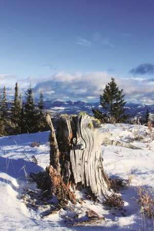
Eventually, the trail breaks out of the dense forest and crosses through open hillsides and rocky outcroppings. The footing becomes more difficult, but the views keep getting better. Note how snowmelt during the day glazes the exposed rock faces with a layer of clear ice. On the windswept summit, look for the few remaining remnants of the 1925 fire lookout, destroyed in 1958. In the distance, pick out the prominent peaks of the Kettle Crest to the east and catch a glimpse of the Cascades to the west.
Keep an eye on changing weather conditions and monitor avalanche forecasts before attempting this hike. On my January visit I didn’t need the snowshoes I carried, but conditions can change rapidly in the high country. Should snow accumulations prove too deep to drive to the trailhead for this hike, use the Sweat Creek trailhead parking on the north side of Highway 20 as an alternate access point. This will add approximately one mile to the trip distance. It’s approximately five miles roundtrip.
Getting There: From Spokane, take Highway 395 north through Colville and Kettle Falls. Cross the Columbia River and turn west on Highway 20. Go over Sherman Pass to Republic. Continue west on Highway 20 approximately 8.5 miles past Republic. Note the Sweat Creek Picnic area on the north side of the road (alternate parking area), and turn south onto Forest Road 31. The trail is on the right in .5 mile; park well off the roadway. No permits are required. For maps, try the USGS Wauconda Summit and the Okanogan-Wenatchee National Forest maps. //